


Precipitation starts this morning.
Flood threat through the weekend.
| A strong low pressure system approaches from the west today. This system has the potential to produce a significant, widespread flooding event this weekend with some river flooding likely persisting into Monday. Much colder air will then take hold for next week as the system departs. Some persistent snow showers are expected for the mountains later Sunday through Sunday night, with several inches of snow and some transportation impacts likely. Additionally, gusty winds are likely across the area, with damaging winds possible in the mountains. Given the saturated soils, tree damage is expected and power outages could be numerous. Another system could bring an area-wide snowfall around midweek, with the best chances for more significant accumulations in the mountains. |
NEAR TERM /THROUGH TONIGHT/...
As of 225 AM Saturday...
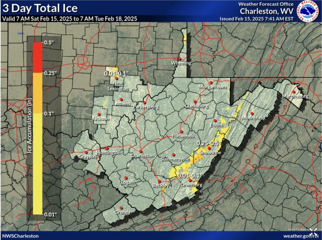
Some scattered echoes have begun appearing on radar early this morning with no precipitation reaching the ground as the low levels remain rather dry. As moisture continues to filter down to the surface as warm advection increase, temperatures will then begin to rise overnight as well, especially across the southern coal fields. Once we begin to moisten up near the surface as dew points rise, we should start seeing some precipitation reach
the ground late tonight, this could potentially fall as snow/sleet or freezing rain across far northern portions of the
forecast area, especially SE Ohio. It doesn`t currently appear that there will be much, if any, in the way of wintry accumulation outside of the mountains but this could cause some
slippery conditions early this morning across northern/northwest portions of the area before the precipitation changes over to all rain.
In the northeast mountains, where the Winter Weather Advisory is in place for most of the day today, it appears with the later
precipitation arrival time than previously anticipated that total ice/snow accumulation could be a bit less than previously expected as well, with the primary impacts being felt across the mountains instead of the lower elevations in the valley. The threat for winter precipitation should end across the mountains by late afternoon, however, heavy rain is still expected thereafter.
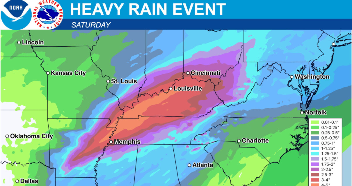
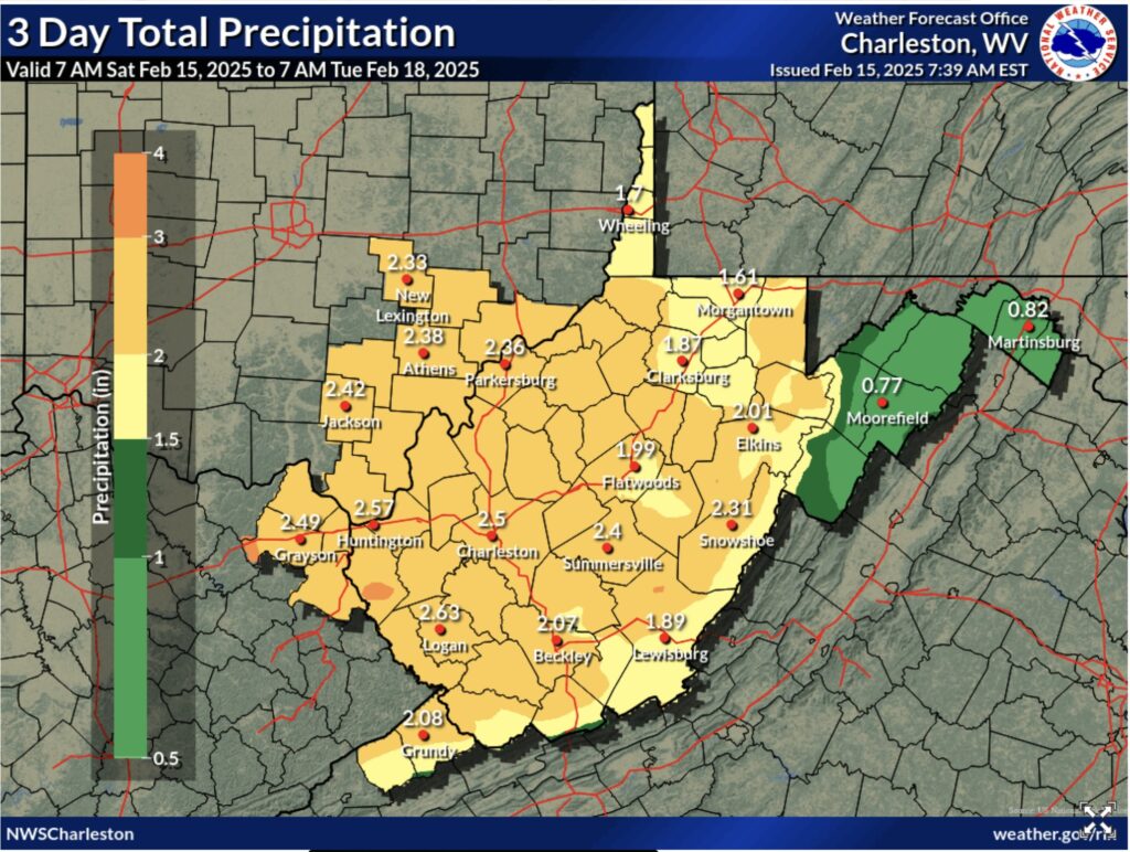
The primary concern today is the potential for significant river and areal flooding as a low pressure system from the Plains combined with a surge of energy from the Gulf, will slide
northeast across the area by late early Sunday, deepening as it crosses our area. Recent model trends have shown that significant rainfall is still expected across much of our forecast area, with the heaviest QPF still situated across southwestern portions of the area. There is still some
disagreement with where the heaviest band of precipitation will align before the frontal passage. Latest HRRR and NAM3km show a narrow band of heavy rain along/just north of the I-65/I-79 corridor training along a warm frontal boundary for several hours late this afternoon into tonight bringing with it a narrow stripe of around 2- 3" of rain, which could greatly exacerbate flooding concerns in these areas as soil remains very saturated and area rivers/creeks continue to run high, especially if this band can become convective. Another area of concern is across the WV mountains and adjacent valleys where current snowpack
across the high terrain could also exacerbate any flooding concerns.
Outside of these aforementioned areas, widespread heavy rain is still expected for a good portion of today and tonight, with
potentially a small break for some areas before the frontogenetically forced precipitation arrives late tonight into
Sunday. A Flood Watch remains in effect for our entire forecast area until 1AM Monday. The risk for widespread flooding will increase with time today, maximized tonight into Sunday. WPC still has much of the western half of the forecast area in a MDT risk for excessive rainfall today, consistent with recent trends and ongoing messaging. There are also ongoing River Flood Warnings for some areas in anticipation of this event, as many
are already at least in action stage and expected to reach flood stage sometime Sunday.
.SHORT TERM /SUNDAY THROUGH MONDAY/...
As of 330 AM Saturday...
Key Points:
* Confidence increasing for an impactful wind event over the higher terrain Sunday into Monday morning, with a High Wind
Watch out for the northeastern mountains.
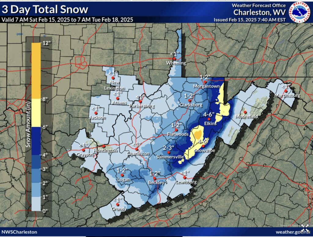
* Several inches of snow appear likely as well later Sunday and Sunday night. Hazardous travel conditions expected, especially in areas susceptible to blowing snow issues.
The cold front associated with this potent system is forecast to be knocking on the door by sunrise Sunday, and will race across the CWA during the morning hours and exit to the east by early afternoon. As it does so, we can expect to see the stratiform rain break up into more showery elements. Most lower elevation locations should see a quarter inch or less of QPF during the day Sunday, while the mountains pick up more than that, with
over a half inch possible in some of the northern mountains. As cold air streams in behind the front, high temperatures will
occur in the morning, with temperatures dropping the rest of the day once the front passes a given location. As temperatures
drop, rain showers will mix with and then yield to snow showers.
Aside from any ongoing creek and river flooding on Sunday, the most impactful weather of this period may be the combined snow and wind expected in the mountains. Momentum transfer in forecast soundings suggests at least a high probability of a strong Wind Advisory event, and with several models showing 60kt winds under the inversion, warning criteria gusts are certainly possible. As a result, and in collaboration with neighbors, a High Wind Watch is in place from mid-morning Sunday through midday Monday for our northern mountain zones.
Additionally, the post-front QPF forecast for the mountains ticked up a bit, kicking the snow forecast for some of our northern mountains into at least Winter Weather Advisory criteria. One or two zones hitting Warning criteria is not out of the question, but given the recent upward shift and in
collaboration with neighbors, we decided to go with an advance notice Advisory for Sunday afternoon and night, rather than a Watch. Given the simultaneous wind event, significant blowing and drifting of snow and reduced visibility is likely for exposed areas in the higher terrain.
Even outside of any High Wind Warning or Wind Advisory area, wind gusts of 25-35mph can be expected behind the front in lower elevations, so at least some tree damage and sporadic power outages will be possible area-wide on Sunday. And not to pile on more, but some of the northern mountains could get close to Cold
Weather Advisory criteria late Sunday night or Monday morning, though it`s very borderline at this point and may be localized to just the highest peaks.


